Explore The Annapurna Circuit Trek With OurGuest

Annapurna Circuit Trek

Places Covered: Kathmandu

88,000  15D/14N

About The Tour

Annapurna Circuit Trek with Tilicho Lake is an adventurous and most wonderful tripthat offers captivating views of nature and landscapes through its trails and the trek goes alongtheside of very popular River of Nepal Marshyangdi along with experiencing the beautiful Apple valley all the way long to Manang.

If we do the trek on spring season, one gets a chance to encounter beautiful and different types of Rhododendrons.This trip offers a lifetime opportunity to experience the beauty of every element of nature and people. 

Tour Packages Details

  • Accommodation in good verified properties during the entire tour duration. 1 room
  • Reserved vehicle for the entire tour including airport pickup and drop.
  • Breakfast included
  • 5 % GST included
 
5% GST included

Pricing Options

  • ₹ 88,000 Per Person (Group of 8)
*Inclusive of GST

Tour Itinerary

Arrive Kathmandu
Day - 1

Arrive Kathmandu

Day of Arrival. The travel from Kathmandu International Airport to Thamel. Hotel is not much around 8 Kilometers but because of traffic it might take minimum 30 mins, our guidewill be there to receive you in the airport. Post legal procedures at the airport, you will betransferred to the hotel booked for you by a private car. Check in at the Hotel.

Todayweneed a full afternoon rest for acclimatization and later the guide will be there to checkall the trekking gears that is needed for trek if anyone is sort or forgot to carry one canbuy. Your guide will give the suitable time for his visit. One can buy cheap trekking cramponsif needed as instructed by your guide as Throng Pass can be covered with snowand will beeasy to hold a grip on it.

Kathmandu - Besishar
Day - 2

Kathmandu - Besishar

Transfer to Besisahar by private Jeep. Distance from Kathmandu to Besisahar is about 175.5 km taking about 7 to 8 hrs depending upon the traffic. Today we will drive alongthevery popular River of Nepal named Trisuli which is mostly famous for River Raftingandlater following Marshyandi River all the way to Besisahar. Briefing sessions for thetrekking. The journey will pass through hill side settlements, rivers, bridges, waterfalls andmany beautiful villages. Lunch on the way.

Besisahar - Chame
Day - 3

Besisahar - Chame

Post breakfast we will continue with our journey for 66.5 km taking 6 hrs to Chame. The journey will be by private car (jeep). As mentioned, the road fromBesisahar toChame is not pitched and must book private vehicle and sometimes one might needtoshare jeep depending upon the vehicle availability. Our guide will be there to arrangeeverything for you. Night stay at Chame. Taste some authentic food for dinner. We thenrest for the following day. Lunch on the way watching alongside beautiful waterfall.

Chame - Pisang
Day - 4

Chame - Pisang

The first day of walking today therefore we’ll gradually start our hike carrying all theneeded equipment instructed by the guide to Pisang for 13.7 km taking 6 to 6.5 hrs. Wemust start our hike on the main road with multiple shortcuts in between. We will start togain some elevation and walk through some narrow and steep valley, where you will betaken care for your utmost safety.

On the way we will enjoy the mystique views of themighty Annapurna Massif in the outskirts, we will also get to witness the sight of PaungdaDanda Rock Face that rises 1500m above the river which is a subsidiary of Pisang Peak.

Pisang - Manang
Day - 5

Pisang - Manang

Post breakfast we will start trek towards Manang valley. On the journey we will walkpast Tibetan settlements, exploring the Buddhist culture. Again, the hike is gradual upgainingabout 400m taking 8 hrs walking mostly on rough roads as the road goes up all the waytoKhangsar village (last village settlement of Manang Valley). Overnight stay at Manangas wefeel the change in the temperature. The following day we hold at Manang itself toacclimatize ourselves for the rest of the journey. As day's activity, we will explore the nearbyareas such as Barge Monastery, the largest one in Manang.

Do a short hike up to GangapurnaLake and the Base Camp. Here we will get views of Annapurna III, Tilicho, PisangPeak, and Chulu peaks which are simply mesmerizing. Manang is probably one of the biggest andvery popular village on this trekking trail. Lunch on the way.

Acclimatization at Manang
Day - 6

Acclimatization at Manang

It is really very important to make a hault at Manang for acclimatization and also to explorethe beauty of this village as the next day hike will going to be above 4000m. Today onecanhike up to Gangapurna Base camp (3800m) or towards the Monastery with the sameelevation but to the opposite side of the glacier. The hike will be about 4 hrs. BacktoManang for Lunch.

Manang (3,560M) to Shree Kharka (4,045M)
Day - 7

Manang (3,560M) to Shree Kharka (4,045M)

After a good acclimatization day at Manang today, we have an easy day hike to Shree Kharka. Normally trekkers head to Tilicho Base Camp from Manang but we will take an easy walk to Shree Karka. We do this because we want to make sure that we are well acclimatized before hiking to Tilicho Lake.

Our destination for today is Shree Kharka which sits at an altitude of 4,045M.

It takes not more than 5 minutes to cross through the village and at the end of these stone houses are large fields of crops growing in the region, blades of green sway to the tune of the winds in stretches of hexagonal land with the backdrop of Gangapurna and Annapurna II, III, IV all dressed in white. The bright green of the fields with the river snaking out to find the place where the land meets the haze down below, the browns from the stone houses somewhere in the middle of the landscape as you look back and the white of all the snow-capped giants above, the beauty and the magnanimity of this scene is overwhelming yet humbling all at the same time. After half an hour of walking, we see a diversion – a road that goes down and a trail that goes straight up ahead. We take the narrower trail straight up which is a trekking trail. Fifteen minutes on the trail and we hit a cable bridge which takes us to the other side of the river. Half an hour after the bridge we find ourselves on a broad road again – a metal gate opens up to say ‘Welcome to Khangsar’. Twenty more minutes after the gate and we reach the village of Khangsar. Tea houses are aplenty in the village – a good place for some hot tea and snacks before we go ahead.
Another half hour after leaving from Khangsar and we hit another split in the trail – one broad road going to the left which is used by vehicles and a narrow one that goes up. We take the one that goes up – although it is steep for about 200M, but it is much  shorter than the broad road which takes you around and then up. The markings to indicate the trail go towards the broad road, but the narrow trail straight up takes you to the same place. After a forty minute climb, and a short way further, we are at our destination for the day. The trail to Shree Kharka is beautiful through and through but especially after the bridge. Temperatures here drop to 6-7 degrees by evening and dip further down at night. It’s no worry though, because the tea houses here are amply cozy with comfortable beds, warm meals and blankets thick enough to keep the wind from getting to you
 

Shree Kharka (4,045M) to Tilicho Base Camp (4,110M)
Day - 8

Shree Kharka (4,045M) to Tilicho Base Camp (4,110M)

We have breakfast by 07:30 and leave by close to 08:00 AM. We start off on a path resembling yesterday’s - climb up a steep 100M incline after which the trail is like humps on a camel’s back – goes up and down over and over again! Half an hour into our day, we cross over to the other side of the river using a bridge. The bridge runs over a deep gorge with the river bubbling underneath. The mountains here are dry with pillars of mud shaped like massive termite mounds which dominate the scenery and add to the drama of the landscape. The route on the other side of the bridge is precarious as it climbs up on barely a trail on a crumbling mountain, for the lack of vegetation to hold its surface, with a vertical drop into the gorge. This section is just about 50M before we get to the safe trail again which climbs up on an incline but is sturdier and provides for firm footing.

The entire trek for today is on sliding trails going up and down on slim paths along the very edge of the crumbling mountain face. The trails get narrower, the mountains get grander and the views more spectacular.  After an ascent of close to 400M for the day, expect to reach deserted mountains of Tilicho Base Camp by 11 AM. The day today ends quickly but do go around the trails on these barren mountains in order to be better acclimatized for the days to come where we will only be going further up..

Tilicho Base Camp (4,110M) to Shree Kharka (4,045M) via Tilicho Lake (4,920M)
Day - 9

Tilicho Base Camp (4,110M) to Shree Kharka (4,045M) via Tilicho Lake (4,920M)

We leave as early as 04:30 AM with our packed breakfast. We climb through dry mountains full of mud and gravel with the river down below and snow-clad mountains on the other side. Depending on how low the temperatures dipped to on the previous night, we might also find morning dew frozen solid on top of the few blades of grass on the side of the narrow trail and few of the last purple flowers you will see today. The air is dry and so is the terrain. When the sun comes up behind you, it is nothing short of magical – the sudden light on the trail, the properly defined rays from behind the mountains bringing everything in your surroundings to life. Landslides have broken some parts of the well-defined trail making them slippery and hard to walk on – rolling stones make it even more difficult. After walking the endless hairpin bends that the trail to this high-altitude lake is made of, we enter the snow area 2.5 hours into our day. After a steep and continuous ascend where we gain as much as 800M, we reach a sign board which indicates the way to Tilicho Lake. The sign post and the blue and white pole, which is used to mark the path all the way up to the lake, brings with it a sort of optimism that the lake is close by. he 6 kms to the lake from the base camp take close to 3-4 hours. There is a board there which gives you all the details of the lake.

After spending a bit of time here, we head back down to the base camp through the same route. This time around, it seems shorter because it’s mostly descent. We reach back down to the base in less than two hours. We take some well-deserved rest here, freshen up, have lunch and sit by the fire to dry ourselves out after our early morning escapade. Tilicho Lake has been a nice detour, but now we have to go back to the trail which takes us around the massif. We leave the base camp shortly after enough rest and food, in order to make our way back down to Shree Kharka.

The 7 kms to Shree Kharka should take us a little more than 2 hours since it’s a familiar route and we are losing altitude.

Shree Kharka (4,045M) to Ledar (4,240M) via Yak Kharka (4,000M)
Day - 10

Shree Kharka (4,045M) to Ledar (4,240M) via Yak Kharka (4,000M)

After a good half day’s break yesterday, we set out for Ledar by 8:00 AM. It is 10 kms to Yak Kharka and an additional 3 to Ledar. Yak Kharka has a lot of options for stay, but it makes more sense to cover a bit more distance for tomorrow and get ourselves to Ledar.

Not too long ago, Yak Kharka and Ledar were abandoned stone shelters, completely ignored by trekkers going up to Thorang Phedi. But ever since altitude’s starting getting a bit more respect, these places are being looked to as legit stop-holds by trekkers on their way to the foot of the pass. Since then, these places have seen the opening of some very comfortable lodges and decent cafes.

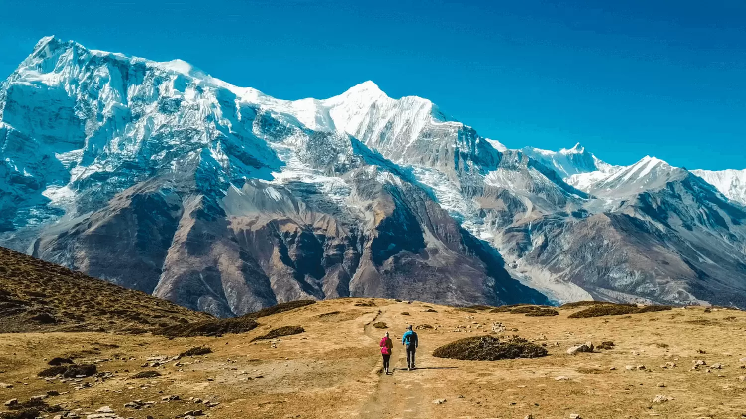
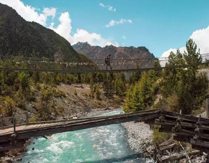
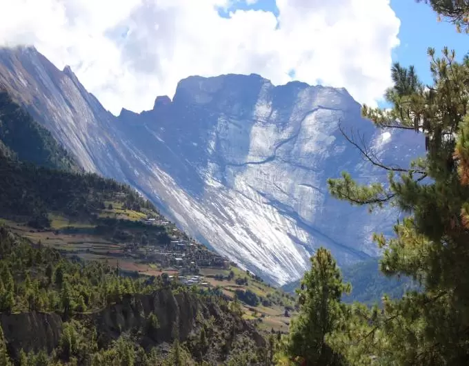
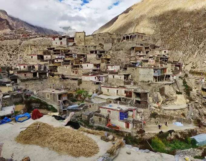
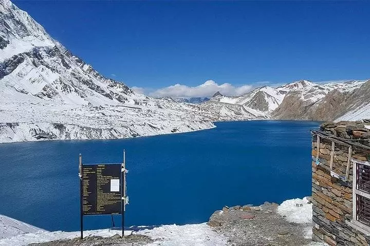
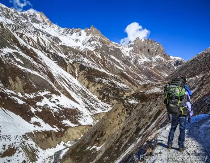
The gradient is not so steep, but it may feel difficult because of the altitude. Half an hour into our day and a 120M ascent, we get to the abandoned village which is now all but ruins of what once might have been a thriving local settlement. An hour and half into our day, we reach to the top of a hill with the most magnificent view of what lies below. A meandering river snaking across the landscape, village at the foothills surrounded by lush green agricultural land spread out in various geometric patterns, the peculiar termite mound-like structures spread across the view – you can see the entire valley for kilometers ahead with Gangapurna, and Annapurna II, III, IV standing tall looking down at the same view as us. From here, we make a steep half an hour descent and lose all the height we gained and then some. Once we get all the way down, we cross over to the other side on a longish bridge swinging right above the river. Over to the other side, it’s all uphill from here. We once again have to make up for all the loss of altitude. There are a few tea stalls here just in case you need to regain some of that lost energy.  An hour and a half after we begin to ascend again, we are at Yak Kharka. The trail is well marked with coloured stripes on every rock you find on the way, so there is no question of getting lost. Yak Kharka has a few options if you want to have your lunch here. If you can hold out for one more hour, you can directly reach Ledar and have lunch there after you settle into your accommodation

Ledar (4,240M) to High Camp (4,850M) via Thorang Phedi (4,540M)
Day - 11

Ledar (4,240M) to High Camp (4,850M) via Thorang Phedi (4,540M)

We leave early by around 07:30 AM. After a steep ascent of 150M which takes close to 40 minutes to cover, we hit a small patch of descent and then a flat trail for 10 minutes. 

The route is well marked all the way – look for red and white stripes on rocks which are marked at regular intervals. At the 50 minute mark, we reach a diversion. There are two paths, one which continues forward and one that goes down to the suspension bridge. Both of these take you to the same place so you can pick either. If you have developed a taste for swinging metal bridges, then this route would suit you well. For each route there is a steep incline after crossing over to the other side of the river – of only about 35M.

The 5 kms from Ledar to Thorang Phedi should take close to 2 to 2.5 hours. Encircling Thorang Phedi are ragged cliffs, crags and ridges. High Pass is a 310M steep incline on crumbly but well-defined trail through the last boulder area for the day – it should take less than an hour. Since we get to Thorang Phedi by 10:30 AM, we have all day to leisurely climb up the 310M to High Pass – there is absolutely no rush.

High Camp (4,850M) to Muktinath (3,765M) via Thorang La Pass (5,416M)
Day - 12

High Camp (4,850M) to Muktinath (3,765M) via Thorang La Pass (5,416M)

We start early right after breakfast by around 5 AM. It still isn’t bright enough yet – we will be climbing in torchlight; so be extra cautious. The trail which zigzags up and up is extremely narrow and can get slippery with patches of ice and moraine. Make sure that you have enough battery in your head-torch for you might need it for at least the next 2 hours. If you stayed back at Thorang Phedi the previous night, you might have to leave even earlier and cover more distance in addition to gaining more height. So get your resources in place accordingly. It is important to carry at least two liters of water since the climb is extremely tiring and the air very dry – keeping your throat wet with water might help make it feel less scratchy. The first hour is truly tiring as you climb up a narrow gully in the thick of darkness. 

Given that it is all a continuous and rather steep ascent, it helps to set a pace and maintain a rhythm. The entire trail is through soft, dusty mountains which seem like you could blow them out of existence. The last bit to the pass can be a bit of a frustration as a series of false summits make an appearance.  But the 4 kms to the pass take not more than 3 hours. Remember never to take altitude too lightly, always be wary of your body and listen to what it’s trying to communicate to you. When you get to that and feel yourself being pushed in all directions by the deafening wind, know that you have reached the infamous Thorang La Pass. 

 It is not a good idea to be exposed to these winds at this height for far too long. It’s going to be a long, hard, tiring journey down to Muktinath through miles and miles of deserted mountains with not a sign of any settlement into the far distance towards the horizon. It is a good idea to stop and admire the magnificent landscape across the Kali Gandaki Valley as it changes form and colour. The trail snakes down the dry land on ridges and moraine. There are a lot of mountains to spot and name but the highlight is when the mighty Dhaulagiri makes an appearance. Remember at the end of the sharp and endless descends awaits a hot shower and some mouth-watering food! Oh and Wi-Fi is back!

Muktinath (3,765M) to Jomsom (2,880M) then fly to Pokhara
Day - 13

Muktinath (3,765M) to Jomsom (2,880M) then fly to Pokhara

Today is the last day of the trek as we head out to Pokhara. If you thought that you have seen all the beauty there is to see on this trek, you are in for a surprise. The specialty of Annapurna Circuit Trek is that each day on the trail is a worthy climax to this story. There are many ways to get from Muktinath to Jomsom including buses/jeeps. Today one has to start early as the way to Jomsom is not pitched and is rough and takes around 2 hrs. with the beautiful view of Dhaulagiri and Nilgiri. After reaching, check in to airport and fly to Pokhara which takes 20 min. Note: One has to be at Airport on time as after 10 AM the weather gets windy and there is always a chance of flight cancellation.

Pokhara - Kathmandu
Day - 14

Pokhara - Kathmandu

After a full day relaxing at Pokhara, we will drive back to Kathmandu. Transferred to the hotel where a farewell dinner will be organized

Final Departure
Day - 15

Final Departure

Time to bid goodbye. We will see you off to Tribhuvan International Airport 3 hours before your schedule flight.